
HIKES & EVENTS
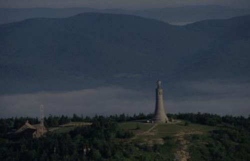
Mt. Greylock
Full Day Hike
DATE: Apr 06, 2024
END DATE: Apr 06, 2024
Hike/Event Location: Adams MA
Trip Leader(s)
Twigs
Townsend, MA United States
Meeting Time: 9:00 AM
Max # People: 25
Hike Guiding / Event Fee: No, I will not be asking participants for money
Hike Difficulty Level:
Strenuous
(Do you qualify to attend with this hike difficulty rating? Click Here.)
Sign Up To This Trip/Event
You must be a least a guest member to participate. Comments such as "+1" or "bringing a friend" are NOT permitted. All participants must sign-up for the event individually.
Select your mode of transportation, make any comments and then click on button.
You are not logged in.
Please, Log In
Summary
 B.B.T.S. Black and Blue Trail Smashers!
Mt. Greylock (3491') - Prospect Mountain (2690') - Mt. Williams (2951') - Mt. Fitch (3110')
This trip is in preparation for the Grand Canyon Rim-to-Rim-to-Rim Adventure. This trip features half the distance without the 100-degree heat, scorpions, rattlesnakes, or tarantulas. This is open to all with the understanding that this will be a STRENOUS hike with STEADY PACE. This is NOT a beginner or season starter.
Total Distance is 14 miles (round trip)
For specific trail specs and details please contact the trip leader directly
This trip is considered STRENUOUS.
Steady/quick pace!!
Rocky trails
Steep Grade (48% inclines & declines)
Open Ledges
Stream Crossings
Remaining snow conditions are possible.
https://footpathapp.com/routes/c42c5d3e-8ffb-42a8-b2a5-51d9876b84e7
The group (Everyone) will meet at the end of GOULD ROAD, ADAMS MASSACHUSETTS at 9 am Sharp. This hike will start and end at the same location.
PREPARATION/WHAT TO BRING: The mountains can have unpredictable and extreme weather changes year-round. It is recommended that hikers have extra dry clothing and wind protection. Always have water and food. If you need suggestions on what to bring, PLEASE ASK!!
Bascom Lodge - was closed as of 3.30.24
For this trip, it is important to bring along flexibility, patience, and a sense of humor.
Group Size It is not fun leaving folks out.
If you cannot attend, PLEASE cancel so others may join.
If you are on the waiting list, please contact me days before the trip, most likely there will be room and if needed this trail will allow us to break the group into two smaller groups.
Please do NOT bring any dogs on this hike.
Decreasing the impact on the environment is always a priority! Please plan to “carry in and carry out” all items. It may also be possible to collect other hikers’ debris along the way.
Weather: If the weather is a concern any updates or cancellation information will be posted by the Thursday before 6 pm. If there is a cancellation, it will include a “possible” rescheduled date so participants can watch for that opportunity.
Safety is a priority! Any time a hiker is injured or lost a HUGE team of volunteers is dispatched to aid in the search and rescue efforts. No one wants to be injured or put others in harm’s way. Always be prepared. Know your limits. If you have any questions, feel free to contact the hike leaders.
B.B.T.S. Black and Blue Trail Smashers!
Mt. Greylock (3491') - Prospect Mountain (2690') - Mt. Williams (2951') - Mt. Fitch (3110')
This trip is in preparation for the Grand Canyon Rim-to-Rim-to-Rim Adventure. This trip features half the distance without the 100-degree heat, scorpions, rattlesnakes, or tarantulas. This is open to all with the understanding that this will be a STRENOUS hike with STEADY PACE. This is NOT a beginner or season starter.
Total Distance is 14 miles (round trip)
For specific trail specs and details please contact the trip leader directly
This trip is considered STRENUOUS.
Steady/quick pace!!
Rocky trails
Steep Grade (48% inclines & declines)
Open Ledges
Stream Crossings
Remaining snow conditions are possible.
https://footpathapp.com/routes/c42c5d3e-8ffb-42a8-b2a5-51d9876b84e7
The group (Everyone) will meet at the end of GOULD ROAD, ADAMS MASSACHUSETTS at 9 am Sharp. This hike will start and end at the same location.
PREPARATION/WHAT TO BRING: The mountains can have unpredictable and extreme weather changes year-round. It is recommended that hikers have extra dry clothing and wind protection. Always have water and food. If you need suggestions on what to bring, PLEASE ASK!!
Bascom Lodge - was closed as of 3.30.24
For this trip, it is important to bring along flexibility, patience, and a sense of humor.
Group Size It is not fun leaving folks out.
If you cannot attend, PLEASE cancel so others may join.
If you are on the waiting list, please contact me days before the trip, most likely there will be room and if needed this trail will allow us to break the group into two smaller groups.
Please do NOT bring any dogs on this hike.
Decreasing the impact on the environment is always a priority! Please plan to “carry in and carry out” all items. It may also be possible to collect other hikers’ debris along the way.
Weather: If the weather is a concern any updates or cancellation information will be posted by the Thursday before 6 pm. If there is a cancellation, it will include a “possible” rescheduled date so participants can watch for that opportunity.
Safety is a priority! Any time a hiker is injured or lost a HUGE team of volunteers is dispatched to aid in the search and rescue efforts. No one wants to be injured or put others in harm’s way. Always be prepared. Know your limits. If you have any questions, feel free to contact the hike leaders.
Directions To Trailhead Parking Lot
The group will meet at 9am SHARP at the end of GOULD ROAD in ADAMS MASSACHUSETTS.
It is a small parking lot, but you can park around the road as well.
if you need help with this for a GPS just ask.
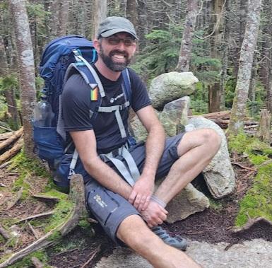
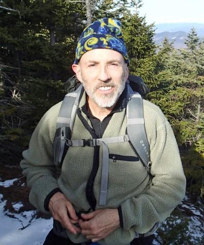
Trip Leader
 Invite To Be Your Buddy
 Send Email
- Online Status: OFFLINE
- Last Login: 04/24/2024 05:13 AM
- Member Since: 08/18/2022
- Approved By: Gandalf
members signed up for this event

- Online Status: OFFLINE
- Last Login: 04/13/2024 12:41 AM
- Member Since: 10/07/2023
- Driving My Own Car
(Possibly willing to give guys a ride)
- Online Status: OFFLINE
- Last Login: 04/24/2024 09:08 AM
- Member Since: 01/24/2009
- Driving My Own Car
(Willing to give guys a ride)

Sounds great, will be prepared and bring snowshoes.
Because of this storm it looks like I will be working this weekend. If anything should change I will let you know. Be safe on the trails, take lots of pictures and leave only foot prints.

Saturdays weather seems to be improving. Tho this weeks storm could be dumping up to 12" of snow in the Berkshires. Knowing these trails it won't surprise me if we are breaking trail for some of this hike. If you have snowshoes toss them in the car. We can make the call at the trail head if we need them or not. Mirco-spikes will definitely be needed. Nicolasmadera -- I got my extra set packed for you.
Nicoladmadera I have just sent you an email threw the website. Please read it and reach back out. Thanks just want to touch base and answer you questions as accordingly.

Hello everyone! How cold it could get all along the hike? What would be some essential items to take to be well dressed for the weather? Thanks in advance. This is going to be my first hike and I don´t want to underestimate the weather conditions.
So this hike isn't in all trails, as I don't use that app. I have created this hike using the app called footpath. If you use the link https://footpathapp.com/routes/c42c5d3e-8ffb-42a8-b2a5-51d9876b84e7 that should take you to the planned route. Dpbyrnes I'll message you with the trail names. In the order as we will climb them. As for the GPS LOCATION FOR PARKING IT IS.. ( 194-156 Gould Rd, Adams, MA 01220 ) or use ( 42.6270417, -73.1448534 )
Hey Jason, longer distance good with me! I booked a place in Williamstown for Friday night and the weather looks good for Friday/Saturday although maybe snow on Thursday? I'm assuming the hike will be a go. Yes please post the GPS coordinates just so I'm 100% of the meet up location. I was hoping to find this route in All Trails but I don't think it's there - does this hike have a particular name? Or, can you tell what what trails it is using? thanks for all!!
Hi everyone. Yesterday I did a quick hike up and around mt. Greylock to test some trails and trail conditions... due to trails being closed and completely flooded I have changed the rout a little bit. It's now closer to 14 miles than the original 12.6miles. Trails overall were muddy. Mirco-spikes were needed for the summit as it was compact snow and ice.
 |
 |
